After years of constant and ongoing planning coupled by setbacks and obstacles in funding, the Manam Resettlement Plan has been conceptualized by professional IT and GIS mapping officers.
It has been a painstaking process for the Manam Resettlement Authority (MaRA) as they have been under financial constraints.
Currently MaRA’s goal is to resettle the Manam Islanders by 2026 in their proposed site of Andarum. Their development focus work areas cover three Districts and Five LLGs and four main work locations (care centers and host villages, Manam & Boisa, Andarum resettlement site and Daigul state land portions).
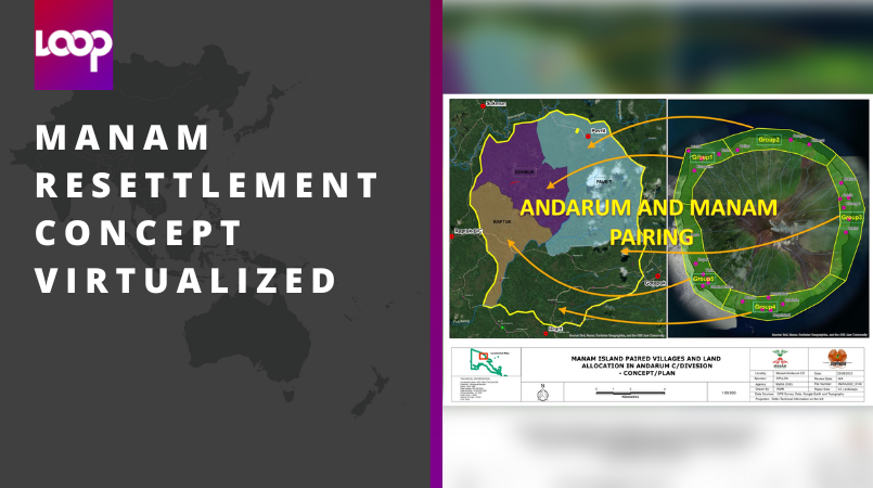
The actual area of Andarum is actually a circular portion of land amounting to more than 5000 hectares. The piece of land sits in two districts of Bogia and Middle Ramu in Yawar LLG and Josephstaal LLG respectively. One third of it sits in Yawar LLG of Bogia and two thirds of the land is in the Middle Ramu of Josephstaal LLG.
The IT and GIS teams have distinctively mapped out Manam Island and the Andarum land area in order to merge all villages in actual positions as aligned on the map. This would create a virtual set up of the Island and when people moved in to the resettled area, it would be of the same set up as how they were on the Island.
The only difference being the location, as these Islanders will make the mountainous terrain their home.
This move, as explained by MaRA, would enable the displaced Islanders to recoup their lives, in the hope that they can rebuild not only their lives, but revive the way they lived before, their cultures, traditions and allies.
In their current stay at the care centres, all villages are squatted in one location, even rival clans and villages. This has had drastic negative social impacts such as intermarriages occurring between banned tribes, anti-social behaviors amongst youths, desensitizing taboos and its practices (Kukurai system) and conflicts within themselves and the host villagers.
A presentation has been done and given to John Rosso, Deputy Prime Minister and Minister for Lands and Physical Planning, in the hope that it should kick start land negotiation talks between landowners of Andarum and the District Lands of Bogia and Middle Ramu to acquire the land legally.
Villages within the resettlement site will have to vacate after registering ILG’s and signing documents with land rights to the respective District Authorities. From there, the land has been specifically dissected into 1 hectare per family which now will be tenured to the settlers with titles.
For now, Land Boundary ID survey has been done, along with the concept design, whilst survey and pegging of allotment pending.
Concerns and challenges for MaRA are;
- Fund constraints, recruitment of personnel, lack of road work plant and equipment Mara Act 2016 Review- PNG National Resettlement Authority Act and Physical Planning Area Declaration for Daigul Land Portions
- Support for Land Acquisition, Land Tenure Conversion, Valuation and Survey from Department of Land & Physical Planning