The current El Niño event over the tropical Pacific could be on track to be one of the strongest in more than 60 years, experts have claimed.
Forecasters from the UN's World Meteorological Organisation are also warning the weather phenomenon may gather strength and reach its peak between October and January – with its effects felt for many weeks afterwards.
El Niño events happen every few years when the wind shifts in the Pacific Ocean along the equator.
It can have devastating consequences for agriculture and disease and influences heavy rain in North and South America and higher temperatures in Asia and Africa.
According to the UN body, surface water temperatures in eastern-central parts of the Pacific Ocean are expected to be 2C higher than usual, well above the threshold for an El Niño.
Similar El Niño events took place in 1972, 1982 and 1997, and each lasted for about a year on average.
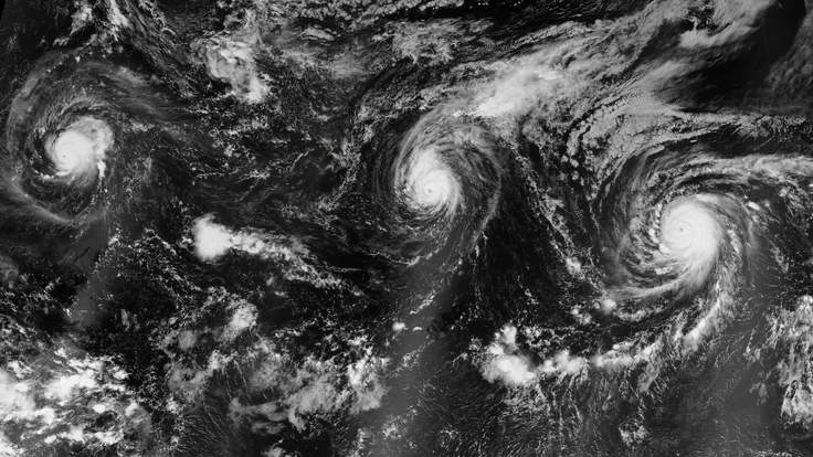
The WMO's prediction came days after NASA's Earth Observatory released images of three Category 4 storms travelling across the Pacific Ocean simultaneously.
Hurricanes in the Pacific are generally solitary storms – and although they do occasionally show up in pairs, three in the same area is unprecedented.
NASA's pictures, from west to east, show hurricanes Kilo, Ignacio and Jimena.
Hurricane Ignacio was the closest to Hawaii with sustained wind speeds of 140mph an hour.
But it has rapidly weakened and is travelling further away from the Big Island.
However, Hurricane Jimena remains a powerful Category 4 storm with maximum sustained winds of about 130mph.
According to the Central Pacific Hurricane Centre in Honolulu, high surf could reach south and east-facing shores in the coming days, and its forecasters are warning the swells could be life-threatening.